Pictures. See series of pictures, called Ice Age Floods.
Next, I'll introduce, The Geology, and the Great Ice-Age Floods
The series of pictures, include the floods route, Crown Point, Dry Falls, Portland, native Americans, and Glacial Lake Missoula.
The Geology.
All the water falls today, as well as the Gorge itself, were formed by.
Geologic chance.
It's a story of 2 great floods.
One of the greatest volcanic eruptions on the face of the earth, starting about 17 million years ago, the Columbia River Basalt Floods, traveled some 400 miles from North Eastern Oregon and western Idaho, originating from the Yellowstone Super Volcano hot spot, located under southern Oregon at that time, as we discussed earlier. Those were the 1st great floods. Lava floods.
Then later, The 2nd great flood, the largest water floods on earth, known as the 'Missoula Floods', or Ice Age Floods, occurred at the end of the last ice age, between 14 to 18 thousand years ago.
The Ice Age, Missoula, Floods, ripped off cliff faces in the Columbia and Willamette Rivers, scoured the 40 foot Willamette Falls plunge, at Oregon City, and the 80 foot Celilo Falls, at the Dalles, and created "all" the other waterfalls in the Columbia Basin, including the, largest Falls on Earth, Dry Falls in Eastern Washington state.
See Pictures. Dry Falls.
Dry Falls was 12 times bigger than Niagara Falls, during the great floods.
WOW!
One of the Pictures, picture #2, show the floods route, from Glacial Lake Missoula Montana, to the Pacific Ocean.
12,000 to 15,000 years ago,--
The birth of the Gorge.
The true making, of the Columbia River Gorge.
From here you can contemplate the natural forces that created the scene: Between 12,000 and 15,000 years ago, an ice age dam, holding back Glacial Lake Missoula, an inland sea, in Montana, collapsed, unleashing a cataclysmic flood that blasted through Idaho, South Eastern Washington, and the Columbia River valley.
The wall of water produced Dry Falls, the Washington Scab lands, and shaved off the sides of the Gorge, tearing away the lower slopes, and changed its cross-sectional profile from a V, to a U shape.
Check out its route, in pictures. Picture #2.
It turned gentle slopes into sheer cliffs, and left the streams hanging high on the walls, to form the plunging waterfalls. It is widely believed to be, the biggest floods, ever, to occur on earth, occurring perhaps as many as 50 to 100 times, over 2000 years!
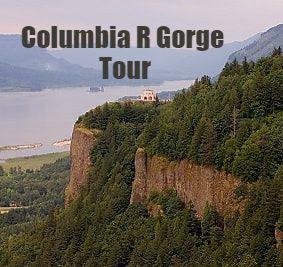
When Glacial Lake Missoula burst, Crown Point, viewed from Chanticleer Point, was the narrowest constriction all along its route from Montana, where all 500 cubic miles of water, were forced between these tall cliffs, only 1.5 miles apart. The flow accelerated from the narrow opening, reaching speeds of 80 miles an hour, before slowing and spreading out over the Portland Basin, topping Portland with, 400 feet of water!
WOW!
See picture, topping Portland with 400 feet of water.
FOLLOW ALONG WITH PICTURES.
See picture #1, the Ice Age Floods.
This painting, PICTURE #1, gives a hint, of the awesome force, and volume, of the Floods, originating from Glacial Lake Missoula.
The viewer’s vantage point, is from Chanticleer Point, looking up river.
It shows the first rush, of the Missoula Floods, coming into the lower Columbia River Gorge, at Crown Point.
Beacon Rock, in the painting, is in the distance, with the viewer looking at Crown Point, in the right foreground, creating a sense of scale unrivaled anywhere in the region.
At maximum flow, the largest of the floods filled the Gorge, overtopping Crown Point.
When we get to Chanticleer point, look at picture #1 in this series again, to appreciate, and better imagine it all.
The flood waters literally shook the ground as it thundered towards the Pacific Ocean.
The animals, woolly mammoths, and saber toothed tigers, and possibly native peoples living here at that time, would have had about 30 minutes vibrational and sound warning to reach high ground, otherwise, they were swept away!
See the last picture in the series, picture #6. Chinook Natives possibly living in the Gorge during the Ice Age Floods.
Let me know, if you want to Learn more, about the Missoula Floods.
And let me know if you want to learn more, about how we learn about the Gorge.
We will be, at our first stop, Chanticleer Point, for about 10 to 15 minutes. Enough time to read the signs, see the view, take pictures, and picture in your minds eye, the great Ice Age Missoula Floods, overtaking Crown Point, depicted in Picture #1.
Also, see a fascinating picture, Glacial Lake Missoula, at Missoula Montana, the origin of the Ice Age Floods. Picture #5.
More interesting info on these images, can be seen in pictures, at, tour Portland dot com, forward slash, pictures.
We will be at Chanticleer Point, in a moment.
Does anyone have any questions?
