Hike #2, is Bridal Veil Overlook - A personal favorite; take the Overlook Trail.
... ... ...
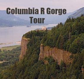
There are many vistas, along the half mile loop path, to view, and for photos of the Gorge.
See pictures. Bridal Veil Falls, and Overlook hike.
Get the best view of the massive basalt cliffs of Cape Horn, across the river. It is a CRBG (Columbia River Basalt Group), rocky Basalt outcrop. An outcrop, is visible exposure of bedrock, or an ancient deposit.
It has received the name of Cape Horn, in consequence of the difficulty of the navigation of this part of the river, arising, from the strength of wind which generally prevails there.
Learn more about Basalt here .
Cape Horn, and Phoca Rock (also called seal rock, and is off shore of Cape Horn), are both named by Lewis & Clark.
"at 17 miles passed a rock near the middle of the river, about 100 feet high and 80 feet Diamuter ...", wrote Captain Clark of Phoca Rock, November 2, 1805.
Phoca Rock is a landslide remnant, the result of undercutting of the Columbia's southern bank, by the Missoula Floods.
Native Americans gathered here to fish, trade and socialize for thousands of years. Historic markers, on the trail, explain the Indian history, geology, and plant life of the area. Native wild flowers such as Camas root was used by the local Indians and given to the Lewis & Clark party for sustenance. Camas, Lupine, bead lilly, trillium and bleeding heart, line both sides of the pathway along the cliff, in the Spring. They were at peace with this beautiful land, and intensely connected to nature.
The Camas plant, a member of the lily family, was unknown to science before the Lewis and Clark journey.
See if you can spot: Cape Horn and Cape Horn Landing, Crown Point, Phoca Rock, in front of Cape Horn. The remnants of the remarkable Pillars of Hercules, which are 2 towering basalt columns, on land, and hidden by trees, and Sand Island, are both to the west.
To learn more about the 1902 Pillar of Hercules Stereo card. See pictures. Bridal Veil Falls, and Overlook hike.
At one time, the Union Pacific rail line went between the two Pillars of Hercules.
Today the rail line is on the north side of the pillars.
The 120-foot-high column once served as a training site for mountain climbers.
You can Find all those sights, on the Overlook Trail.
Good lunch stop for small groups--1 picnic table on the loop trail.
This hike is two thirds of a mile, meaning you'll be back here in about 25 to 30 minutes. Bring the binoculars!
Click HERE, to learn about the ghost town of Bridal Veil, and post office.
Does anyone have any questions?
